


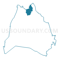
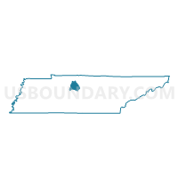
03-1 Union Hill 1st Baptist Church Voting District, Davidson County, Tennessee
About
Outline

Summary
| Unique Area Identifier | 668240 |
| Name | 03-1 Union Hill 1st Baptist Church Voting District |
| County | Davidson County |
| State | Tennessee |
| Area (square miles) | 12.53 |
| Land Area (square miles) | 12.50 |
| Water Area (square miles) | 0.03 |
| % of Land Area | 99.74 |
| % of Water Area | 0.26 |
| Latitude of the Internal Point | 36.36197770 |
| Longtitude of the Internal Point | -86.77463540 |
Maps

Graphs
Select a template below for downloading or customizing gragh for 03-1 Union Hill 1st Baptist Church Voting District, Davidson County, Tennessee


Neighbors
Neighoring Voting District (by Name) Neighboring Voting District on the Map
- 01-1 1st Baptist Church of Joelton Voting District, Davidson County, TN
- 03-2 Joelton Elem School Voting District, Davidson County, TN
- 03-8 Davidson Academy Voting District, Davidson County, TN
- 04-1 Ridgetop Adventist Elem. Voting District, Robertson County, TN
- 10-1 Luton's UMC Voting District, Davidson County, TN
- 10-2 Walker Creek UMC Voting District, Davidson County, TN
Top 10 Neighboring County Subdivision (by Population) Neighboring County Subdivision on the Map
- District 10, Davidson County, TN (18,165)
- District 3, Davidson County, TN (17,192)
- District 1, Davidson County, TN (16,419)
- District 4, Robertson County, TN (5,261)
Top 10 Neighboring Place (by Population) Neighboring Place on the Map
Top 10 Neighboring Unified School District (by Population) Neighboring Unified School District on the Map
- Nashville-Davidson County School District, TN (626,681)
- Robertson County School District, TN (66,283)
Top 10 Neighboring State Legislative District Lower Chamber (by Population) Neighboring State Legislative District Lower Chamber on the Map
Top 10 Neighboring State Legislative District Upper Chamber (by Population) Neighboring State Legislative District Upper Chamber on the Map
Top 10 Neighboring 111th Congressional District (by Population) Neighboring 111th Congressional District on the Map
Top 10 Neighboring Census Tract (by Population) Neighboring Census Tract on the Map
- Census Tract 806.03, Robertson County, TN (4,327)
- Census Tract 102.01, Davidson County, TN (4,041)
- Census Tract 102.02, Davidson County, TN (3,530)
- Census Tract 101.03, Davidson County, TN (2,377)